UPDATE: Maproom pro has been released and the Beta has ended on 2016-11-01. All beta license will be phased out. You can still subscribe to the mailing list of course and get updates about Maproom. Go get Maproom pro here
Last week I’ve sent out the invitation to the Beta of Maproom to the very patient people waiting on my mailing list. Today I’m opening up this Beta to the public. If you want to get started with creating great maps in 3ds Max and help me make a better product along the way, sign up here and you’re in.
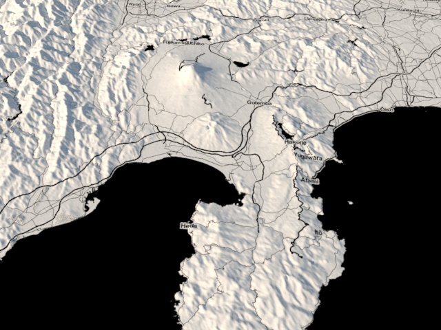
In the meanwhile, take a look how easy it is to build a 3D map of the region around Tokyo.
76 Comments
Join the discussion and tell us your opinion.
Hello, very nice plugin, may I test it, please. Are there restrictions using it?
Hey Vladimir and Johan, I’ve added you to the beta list. You’ll get an invitation shortly.
Maproom is free to use but there are a few restrictions. I’ve written a short article about it on the helpdesk: https://klaasnienhuis.freshdesk.com/support/solutions/articles/12000001615
Hello Klaas,
Can you add me to the beta list as well. Thank you.
Done Joshua, you’ll get the info shortly.
i would really like to get my hands on this too!
Hi Klaas,
Can I test the plugin?
hello ! very nice work. i am wondering is is possible to take a whole country ?
like let’s say Lebanon, but with smaller details.
Sure, you can map an area as small as a street or as big as the world. And anything in between. Check out an example of Lebanon I just made: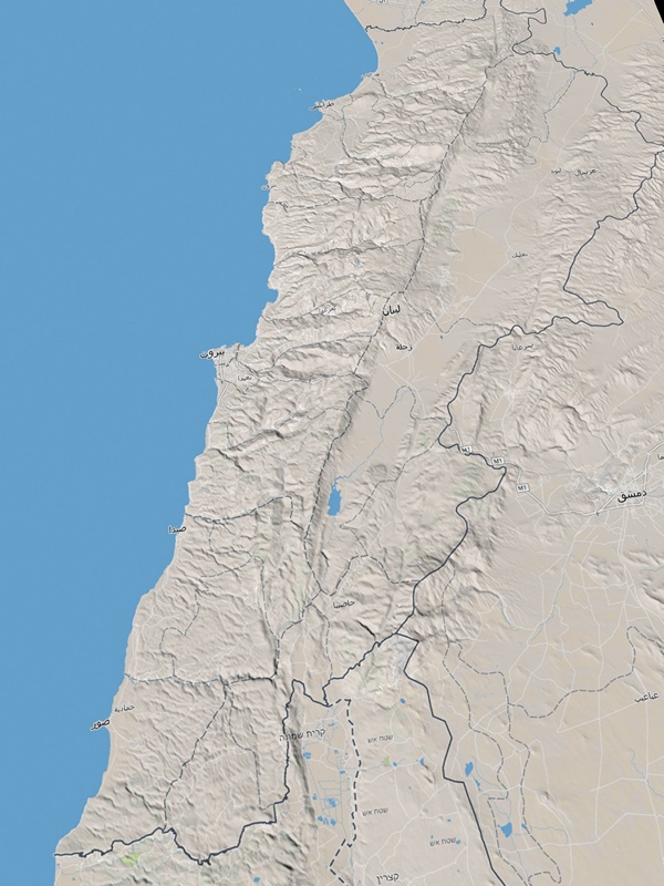
Thank you, j test your plugin, very good work…
Wilfrid,
Hello Klaas
Can you add me to the beta list as well.
Thank you.
Hey people, thanks a lot for the interest in Maproom. If you want to be part of the beta it’s easiest to enter your email address yourself in the post above instead of asking for it in a comment.
Hi Klaas.
So I entered my email address and clicked subscribe but nothing seemed to happen. Should I have received an auto-email or something? How do I test the script?
Thanks Theo
Hi Theo, thanks for signing up. I send out the beta info to new subscribers once or twice a day, it’s not automatic yet. If you bear with me, you’ll get the info shortly.
Great plugin,
Please add me to the beta list…
love to try out many atmospheric effects on it…
Thank you
Hola Klaas. Por favor me añades a la lista. Muchas gracias.
I dream of this script for years. where can we download it ?
Great idea and good looking results! I’d love to be in the beta too!
Greetings from SOA.
Great!? I would like to join beta too!
will we get a video that shows us how to get the gis data (buildings and streets) imported as well and will this data be projected onto the topography maps that this original beta version is showing ?
Hi Chris, osm workflow is at the top of my list right now. Projecting the shapes onto the topography is very slow at the moment. Once I’ve made some progress in that area I’ll release a video about it.
Excellent plugin I would be on the list , it’s just what I needed , please make life a little easier
Hello, could I be added to the Beta as well? for my current real terrain projects I have being painstakingly cleaning .ai files by hand and using the contours with the terrain compound objects, this script could be a dream come true.
Hi Klaas, this tool looks amazing and seems like doing 80% of my work automatically. I would like to join the beta test too.
Hello Klaas
This script looks very intriguing
I would also like to join the beta if possible
Thanks in advance
Please let me try! This is a very useful tool
may i get into your betatest? thanks Nienhuis
Hello Klaas,
I would like to know what langage you use to make your script.
Hi Vincent, It’s divided between maxscript (the native scripting language in 3dsMax) and C#. I saw on Vimeo you also built an SRTM parser for Houdini. Great work!
Thanks for your answer and comment. I made a very simple strm parser for now. Your plug is far better and complete.
I assume you use C# to deal with layered aerial map. Is it right ?
I was looking for a way to deal with aerial map service via Python but without success …
Keep up the good work !
Yes, getting and reprojecting the maps is done in C#. I’d imagine there’s a library for python to do this for you. Downloading the images is the easy part, making sure they match up with the terrain is the challenge!
Oh sure I believe you !
About aerial images, can you please give me the link to the library you use ? It could give me some clue for any python implementation.
No libraries involved. It’s all home-made!
Great work and nice results 🙂 maybe it’s worth to note, that the OSM license (ODbL) is copyleft, so the resulting scenery might be licensed as well under ODbL?
You might want to add yourself to the OSM wiki: https://wiki.openstreetmap.org/wiki/3D_development
There are also already Blender3D folks, which work with OSM
Good catch. I’ve added the attribution info with the osm tiles, but not with the shapes. This is a good source: http://wiki.openstreetmap.org/wiki/Legal_FAQ. If you derive work (partly) from osm data such as a rendering or animation you need to attribute osm but their license doesn’t apply to the derived work. At least, that’s how I read their FAQ.
This is very impressive.
Just saw the video, love what I see and would love to test out if Beta is still available.
Impressive work Klaas, can i take part in beta testing. Thanks Jan
Hi Klaas
our university very interested in this..could you please add me as a beta tester as well,,I am teaching in the Catholic university of America a digital tools courses and we would like to try this beta as well,,
thanks
Hussam
Hi Hussam, just sign up with your email at the top of this post and you’ll get all the information you need.
Hi Klaas,
wonderful script,
I was wondering how much would cost the final version ? And if you plan to integrate Bing terrain ?
Fred.
Hello!
This is a very nice script and I think, it would have a rich future. I want to test this amazing script!
Thanks and have a nice day
I love the look of this, wanting to use this for upcoming projects! 🙂
how can i use ripple feature
it s hiden
Correct, I’ll release it in a couple of days. Bear with me!
Hello Klaas,
Can you add me to the beta list as well. Thank you.
Hello, very cool script!
I have registered but I can’t get a license for the beta, maybe I’m not doing something right! Can I test the script?
Hey awesome stuff here ! Really cool for my work. Can you add me to the beta ? Thank you
Hello Klaas, cool script
may I test it, please?
Hi.
Can you please add me to the beta for maproom as well please..
This is GOLD! This is looking really good, I’m looking forward for the final release, buying a license for sure!
Thanks Wolfgang!
Really nice looking script! I hope to get in the beta. Thank you!
Hi Klaas
I recently signed up for this beta, it seems very usefull. Im from Guatemala And I would like to make a terrain of my city.
Great job by the way!.
Hello Klaas, I registered for the beta within the software as explained in your video, But I am still waiting to be registered (1 month almost), sorry to bother you here, is it possible to be added to the beta? thanks!
Hi Klaas,
I’ve subscribed to the beta. Please activate my username as well 🙂
Thank you !
Hi Klaas
Could you register me for your beta? I would like to try some terrains and cities in Austria.
Thank You
Bozhidar
Hi Klaas, I want to send my congratulation for a so useful tool!
I´ve subscribed sending my email.
Thanks!
PS: Does it work in max 2014? I have max 2016, but I mostly work in 2014
Yes, 3dsMax 2014 works
I have a problem, It says “Maproom can´t connect to the internet…”
Actually the computer I use for production has no connection at all to the internet, neither has a network connnection, is an isolated workstation. I use another computer for navigation (to avoid viruses and for other security reasons)
How can I solve this?
Hi Caroline, thanks for joining the beta. Maproom uses data from online sources, such as Bing or Openstreetmap. The licensing also runs through a server. If you have no internet connection Maproom won’t be able to download any data. It will be basically useless that way, I’m sorry.
Hi Klaas,
Great plugin so far. I only have the ‘satellite’ preset and I can’t seem to load any terrain heights. I’ve tried different locations around the world but my dropdown only says “none”. Any ideas? Using build 0020.
Hey James, to get access to the entire toolset you need to request a beta license. Check out how to do that here: https://klaasnienhuis.freshdesk.com/support/solutions/articles/12000001271-get-full-beta-license
Of course 😛
Thanks 🙂
Hi Klaas,
from what I see, that is an elegant and amazing plugin you created!
I do have a bug report, though (didn’t know where else to put it):
Upon running the script (= clicking the toolbar icon) I get a “MAXScript MacroScript Error Execution” message: “– Runtime error: dotNet runtime exception: Invalid directory on URL.”
Looking forward to future versions!
Hello Klass, it´s me again.
Well I´ve installed max2014 in a computer connected to the internet.
Now I got these two errors:
1- Unwnown property:”value” in undefined
2- –Runtime error: dotnet runtime exception. Must be non negative and less the size of the collection.
Parameter name: index.
And the splash stays forever…
Any suggestions please?
Thanks in advance.
Hello Klaas,
Can you add me to the beta list as well. Thank you.
Hi Nikolai, you can do that yourself. Just enter your email address at the top of this page and hit “Subscribe”. You’ll get all info you need after that by email.
Hi Klaas.
I was using sketch up for terrain and satellite modeling, but they are using lower resolution providers now since their googlemaps license expired. How does your plugin compare to the geolocation resolution of sketchup. Is there a demo I can test since the beta is over?.
Hi Glen. I haven’t used Sketchup so I can’t compare. But you can try it out yourself. Just download maproom from the shop here https://www.klaasnienhuis.nl/wp/product/maproom/. You can make small maps with satellite images but they can be detailed. Maproom doesn’t serve google images though, their licensing costs are insane! Basically, maproom uses what the map providers display themselves. So, in the full version of maproom, if you want to know what detail you can get with Bing maps imagery, go to Bing maps and zoom in as far as you can. that’s what you’ll get in maproom as well, provided you stick with the default map projection.
dude it’s too expensive for me becaue 1 euro=4,5 TL. is there any educational license
Hi Okan, there’s a free version of Maproom. Just download maproom from the shop and you’re good to go. If your school or university purchases at least 20 seats I provide free licenses for the participating students. So: contact your teacher!
Hi Klaas, is there a free version of maproom ? Can we test it somewhere ?
Thanks
Hi Gabriel, you can go to the shop and download and use maproom for free. Maproom has a free mode with limited functionality.
Hello, could you, please tell me why my license has expired? When I bought it, I was sure that it was forever. That’s exactly what it said in the purchase details. But in the license manager there is a limit of 365 days. Where and what did I misunderstand? Thank you.
Hi Vlad, I’m glad the issue has been resolved. These licenses indeed don’t expire